
The flow of water through Earth’s rivers plays a key role in the functioning of the Earth system, by modulating biogeochemical cycles and flux exchanges between the land surface and atmosphere, as well as by transporting nutrients and/or contaminants and sustaining vital ecosystem services. However, flooding has devastating impacts on people and the environment in terms of costs and flood risk.
Costs
Flooding is now the deadliest and most costly ‘natural’ hazard on the planet. There is unequivocal evidence that the frequency and intensity of extreme precipitation events is increasing under greenhouse warming, with flood models projecting that these climate changes will generate substantial increases in flood hazard across the globe in the coming decades.
300 million people are impacted annually by floods.

Flood Risk
Flood risk, the product of flood hazard and the vulnerability and exposure of people and assets, is also increasing because of demographic changes and economic development in flood-prone areas. This will significantly increase the one billion people already living in flood susceptible areas.
Vast population shifts and infrastructure development in floodplains.

Flood Modelling Advances
Global flood modelling has two main components that work together to produce a successful simulation – rainfall and inundation. Accurate estimates of rainfall distribution and intensity are fed into inundation models that reveal what areas will be flooded. The past 10 years has seen notable advances in flood modelling – particularly with respect to rainfall.
Rainfall Component
Advances in hydro-climate science through ensemble predictions and downscaling techniques have improved rainfall distribution and intensity estimates. This greatly improves the basic building blocks used in GFMs.
Flood Inundation Component
Much work has also been undertaken to improve flood inundation models designed to be applied at the global scale, enhancing routing models and digital surface representations.
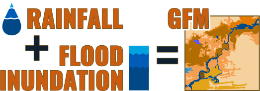
Figure: Coupled framework linking hydroclimatic inputs with spatial flood inundation models.
Global Flood Models (GFMs)
Advances in hydro-climate science through ensemble predictions and downscaling techniques have improved rainfall distribution and intensity estimates. This greatly improves the basic building blocks used in GFMs.
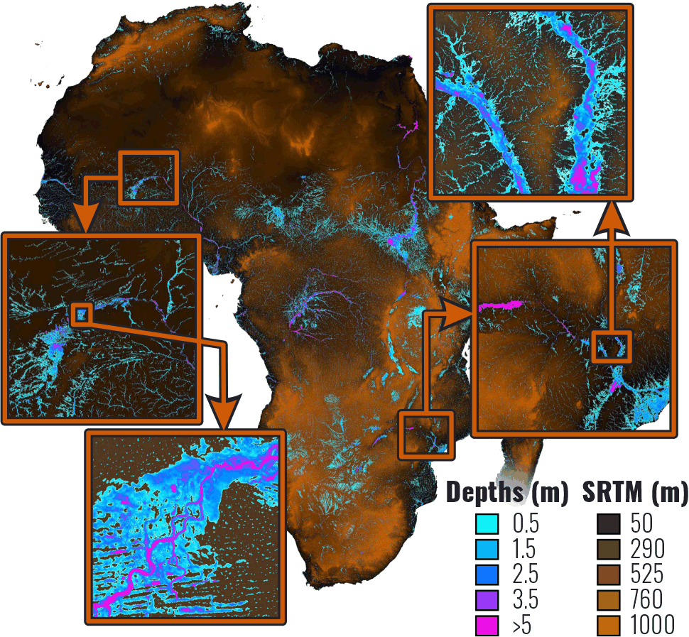
Of particular significance is the emergence of flood inundation models designed to be applied at the global scale. Such an approach is at the heart of understanding how hydrological cycles will shift with climate at the global scale and understanding national flood risk profiles decades into the future.
Indeed, state-of-the-art Global Flood Models (GFMs) are now key tools that scientists are employing to represent the hydrological cycle in Earth System Models (ESMs), and to project how environmental change is forcing altered flood hazard and risk.
The Modelling Frontier
A suite of new scientific challenges have emerged that introduce unacceptable uncertainties into GFM approaches. As a result, our understanding of the magnitudes, locations, and environmental controls on future flood hazard and risk, which is derived from application of GFMs, is likewise limited.
These key scientific challenges, which we will address in this project, are outlined in detail below:
Put simply, we have reached the limits of our capability to model flooding at the global scale.
Scientific Challenges for the EvoFlood Project
Challenges with representing spatial variations in channel conveyance and channel-floodplain connectivity
Current GFMs represent river morphology in ways that have profound implications for their ability to predict flooding.
Channel Morphology
Existing GFMs are initialised by representing channel morphological properties (e.g., depth and roughness) on the river network by assuming that the flow carrying capacity of the river channel (so-called ‘channel conveyance’) can be equated to a discharge with a return period that is spatially invariant (often, but not necessarily, the specified return period is assumed to be the one in two year flood).
Limitation
This assumption of spatial invariance is demonstrably wrong. For example, while some natural floodplains are inundated only once a decade, large wetlands typically flood every year, but even state-of-the-art GFMs cannot reproduce this behaviour. This is a significant limitation in the ability of GFMs to reproduce observed spatial variations in inundation frequency and extent.
When combined with the challenge associated with implementing GFMs at coarse spatial resolution, this leads to unrealistic representation of channel-floodplain connectivity and associated water exchanges, which further restricts the potential of GFMs to represent inundation sensitivity to flood magnitude as well as other inter-connected components controlled by flood processes.
The extent to which inundation frequencies do vary along the world’s rivers has never been quantified before and will be a key challenge for the EvoFlood project.
Challenges with determining the importance of transient morphological change in driving evolving flood hazard
While state-of-the-art GFMs employ problematic spatially-invariant representations of channel conveyance, GFMs also assume that channel and floodplain morphology remain unchanged over time, even over decades.
Limitation
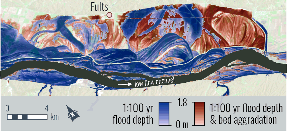
This is problematic because river morphology is both a control on, and consequence of, fluvial processes, hence the floods that GFMs are intended to represent may themselves reshape rivers via erosion and sedimentation, leading to changes in channel conveyance and channel-floodplain connectivity.
Implication
The neglect of these changes means that model predictions of flow depth, floodplain inundation and flood wave propagation can become significantly biased.
In proof-of-concept analyses our team have clearly demonstrated how neglecting such channel changes significantly biases GFM predictions of flow depth, floodplain inundation and flood wave propagation.
Anthropogenic & Climate Influences
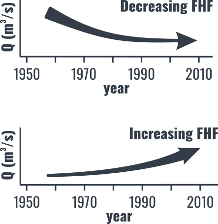
There is clear evidence that landscape-scale changes in river hydrology and sediment loads - the drivers that stimulate the long-term evolution of channel and floodplain morphology - are also changing as a result of climate change and anthropogenic activities.
Climate Change Dynamics
Darby et al. showed how a 30% reduction in sediment flux during 1981-2005 has occurred as a result of climate-driven adjustments in cyclone track locations over the Mekong River Basin.
Direct Modification
Many rivers have been regulated by damming (over 45,000 dams globally) and other large-scale schemes are under construction, with profound impacts for flow regulation and downstream sediment supply. Such reductions in sediment flux are known to amplify flood hazard through a loss of floodplain storage zones, as has been shown on the Yangtze River downstream of the Three Gorges Dam.
Furthermore, our own prior empirical work has also demonstrated that long-term variations in flow and/or sediment supply have driven major changes in channel conveyance, that in turn cause significant shifts in the frequency of overbank flooding, at the continental scale, at least across Europe and the USA.
Hydro-climate Effects
Morphodynamic Effects
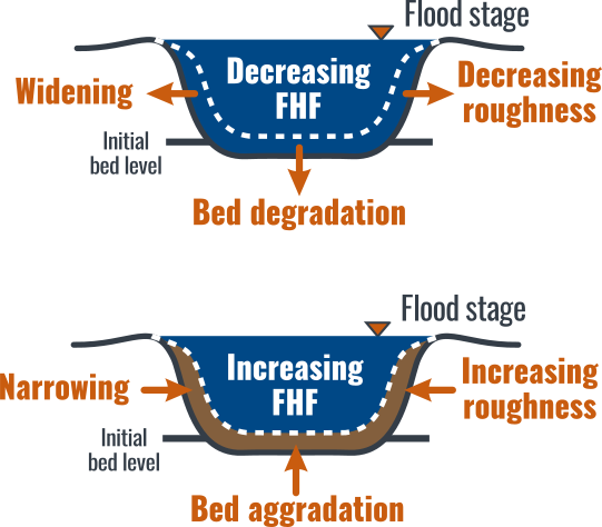
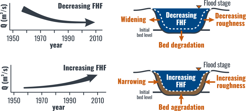
The challenge now is to identify the scale of these morphologically-driven shifts in conveyance and connectivity across the entire globe, and to find ways to represent the effects of such changes within GFMs. Until these issues are resolved, the static representation of channel morphology, as assumed in all existing GFMs, will continue to represent a fundamental source of bias in predictions of future flood hazard at the global scale.
Challenges due to large-scale simplifications made by GFMs
In recent years GFMs have seen notable improvements in:
- Model structure and efficiency
- Estimation of model friction and conveyance parameters
- The specification of model boundary conditions
A fundamental conclusion of these recent advances is to highlight that accurate representation of channel width, depth and floodplain topography is critical for simulating accurately flood inundation and flood wave propagation dynamics.
Existing GFM Simplifications
Several first-order controls on flooding remain entirely neglected or heavily simplified by existing GFMs:
- Global variations in floodplain vegetation that control roughness and overbank stage-discharge relationships.
- The effects of dams, despite their significant impact on flood hydrology, sediment trapping, downstream river morphology and flow conveyance capacity.
- DEM-derived river networks (e.g., HydroSHEDS) that do not represent river location well, especially in areas of subdued topography.
- Treatment of all rivers as single-thread channels, failing to represent anabranching systems or channel bifurcations.
Taken together, these simplifications add additional bias to GFM predictions that further limit their predictive capability. The project will strive to eliminate as many of these biases as possible to increase GFM accuracy.
Challenges of scale and computational cost
GFMs can simulate the probability of flooding across Earth at ~90 m spatial resolution and ~30 m across the USA. However, the computational cost of such simulations is very high, making it infeasible to carry out the large model ensembles needed to quantify adequately model uncertainty. For this reason, state-of-the-art GFMs are more typically implemented at spatial resolutions of 1-5 km, with consequences for their ability to resolve floodplain topography and represent inundation processes.
The past 5 years have seen significant improvements in:
- The resolution (spatial and temporal) of Earth Observation platforms
- DEM (SRTM) error processing
- The availability of new high-resolution and high-fidelity datasets [e.g., TanDEM-X; PlanetLabs]
A fundamental knowledge gap exists in understanding how best to exploit the opportunities provided by these developments, and to optimize the tradeoff between:
To explore the relationships between model resolution and the representation of topography and inundation processes, and the consequences for model accuracy, bias and uncertainty cascades.
Challenges of Coupling Hazard to Exposure and Vulnerability
Understanding how flood hazard couples to exposure and vulnerability is key in predicting flood risk. Significant advances have recently been made in the creation of high-resolution data on human population distributions and mobilities. Such data are a pre-requisite for the accurate management of hazard and the mitigation of exposure and risk, notably in terms of the ability to model and predict population shifts at high spatial and temporal resolution.
Such approaches have significant potential to transform our ability to model exposure and risk before, during and after major natural disasters, such as major flood events, and to inform planning of longer-term mitigation interventions. This is particularly true in terms of developing understanding of the extent to which population centres, and structures developing on floodplains, are exposed to changes in inundation, and how flood risk and vulnerability change in time and space under future climate and environmental change.
A critical challenge therefore exists in coupling re-appraisals of evolving future flood hazard with better constraints on the dynamic evolution of flood risk. These advances would in turn allow a linked evolution of population (with structure, vulnerability, and mobility) to be fully integrated within dynamic global flood risk assessment frameworks.